| bookmark this page - make qweas your homepage | ||
| Help Center - What's New - Newsletter - Press | ||
| Get Buttons - Link to Us - Feedback - Contact Us |
| Home | Download | Directories | Freeware | How to | Free Mac | Store | Mobile | Mac | Guides | Discount | Rate | Updated | Popular |
| Picks | Hot | Reviews | Mac Hot | New Releases | Featured | Search | Top100 | iPod iPhone | DVD | Blu-Ray | iTunes | SiteMap | FAQ |
|
|
FlashMap 1.3A powerful interactive map publisher - it is the best way to share and publish interactive map for web sites, presentations.
FlashMap is a powerful interactive map publisher, is the best way to share and publish your interactive map on the web. You can create a clickable, zooming map written in Flash and colored by many optional color schemas. FlashMap is an easy to use vector to vector converter, so you can zoom in, zoom out the drawing to see any details of the drawing. Key Features:
FlashMap can help us to publish interactive map on the web. It supports zooming in, zooming out. We can set the colour and logo for the map. It is very easy to use. User Comments: [ Write a comment for this software ] No user comments at present! Related Programs:
|


 Download Site 1
 Buy Now $39.95
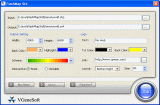

| New
- News - Discount
- Mac Video
- Updated - Freeware
- Windows - Linux
- Developer - Partner
- Resource © 2009 Qweas Home - Privacy - Terms - Directory - Service - Recommend - About Qweas |