|
ALLTRANS 2.32
It can be used for world wide professional coordinate transformations between international and national coordinate systems with or without geodetic datum change.
| Version: | 2.32 |
Publisher: | allsat.de |
| File Size: | 4,517 KB |
System: | Windows 98/ME/NT/2000/XP |
| License: | Free to try ($99.00) |
Limitations: | Demo |
| Date Added: | 03-27-2006 |
Requirements: | none |
Software Description:
With the ALLTRANS you can perform worldwide transformations between State Plane Coordinates, UTM-coordinates, geographical coordinates and 3D-cartesian coordinates. The mathematical accuracy of the transformation within a GK meridian strip has a mean value of around 0.1 millimeter. The GK meridian strip is automatically calculated by default during the transformation into State Plane Coordinates, but it can also be predetermined. (The same applies analogously for UTM.)
ALLTRANS supports manual input and File-Import/Export (ASCII). The manual input of data is checked for erroneous input, which is then clearly indicated. The option exists to store the manually entered coordinates in a file. In the case of data input via file import, the output is also principally sent to a file. The name and directory of the files can be freely selected. The file content can be displayed at any time.
Key Features:
- Transformations can be made between State-Plane-Coordinates, UTM coordinates, geographical(ellipsoidal) coordinates and 3D-Cartesian coordinates.
- Worldwide transformation for all states with specific projections.
- The transformation can be done by manual input or files.
- If coordinates are entered manually, the coordinates can be stored in files. If there is a file-transformation, the transformed coordinates are saved also in a file. Filename and directory are user defined and the files can be viewed and edited.
- If the default-parameters are not of acceptable accuracy, it is possible to calculate and store the parameters by identical points. The calculation of the parameters is done by a standard adjustment (L2-Norm). An outlier test is also possible.
- If the default-parameters are not of acceptable accuracy it is possible to calculate and store the parameters by identical points. The calculation of the parameters is done by a standard adjustment (L2-Norm). An outlier test is also possible.
- With the Geoid-Modul the user can calculate orthodox metric heights from GPS-heights. There is an interface available to the EGG97 up to now.
- For UTM-transformations the UTM-zone can be calculated automatically by the software or defined by the user.
- The accuracy of the transformation is better than 1 mm (no datum shift).
- Online-Help
- Languages English and German.
Editor's Review:
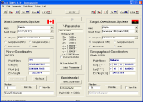
The interface of the ALLTRANS is well-executed; it places more common ones on the toolbar on the in the form of surface. The Start Coordinate System is on the left, the Target Coordinate System is on the right, and in the middle the 7-Parameter and the Geoidmodel. The arrangement of the interface is handy and legible. The transformation in different parameters and different countries is accurate, and ALLTRANS supports both English and German.
User Comments:
[ Write a comment for this software ]
No user comments at present!
Related Programs:
- Petri .NET Simulator - Petri .NET Simulator has been designed for modeling, analysis and simulation of flexible manufacturing systems, but can be used for other discrete event systems as well.
- JupSat Pro - Predict Great Red Spot transit times and times of Jupiter's satellite phenomena including shadow transits and satellite eclipse times.
- physics 101 SE - Physics 101 SE is the premier physics calculation tool
- Winning Science Fair Projects GOLD - With dozens of award-winning science fair project examples, lessons and other tools to help you prepare a winning science fair project.
- Universal Converter - Convert UK and US values to their Metric counterparts and conversely.
- Tom Computer Simulator - It is a computer simulation designed to teach first time users how a computer works.
- Flow Pro - Hydraulic design software for professional civil engineers.
- Pocket Stars PC - Pocket Stars PC is a high accuracy ephemeris, star finder, and celestial navigation tool for the desktop PCs, tablet PCs and notebook PCs.
- DreamCalc Scientific Calculator - Provide a fully featured and convenient alternative to using a separate hand-held calculator when you are working on your PC.
- LunarPhase Pro - LunarPhase Pro provides everything you need to know about lunar phenomena, and include interactive Moon Atlas.
|


 Download Site 1
 Buy Now $99.00